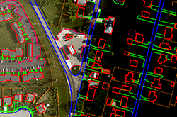
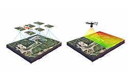
axis@geomatiques.com
  • Facebook
  • Twitter
  • Google
  • RSS
  • Facebook
  • Twitter
  • Google
  • RSS
Axis Geomatiques Solution
  • Home
  • About Us
  • Industry
    • Energy
    • Transporation
    • Mining
    • Emergency Management
    • Environmental Assessment
    • Recreation
    • Forestry
    • Government
  • Services
    • Aerial Triangulation
    • Digital Mapping
    • Digital Aerial Photography
    • Topographic Mapping
    • Gis Base Mapping
    • Lidar
    • Orthophoto
    • Digital Terrain Model
  • Contact Us
Select Page
our services

Aerial Triangulation

Digital Mapping

Aerial Photography

Topographic Mapping

Gise Base Mapping

Lidar

Orthophoto

Digital Terrain Model

Basic

Production Capacity

  • 7 days A week operation.
  • Minimum 2 shifts of working in a day.
  • Extendable to 3 shifts
Weekly

Production Capacity

  • Aerial Triangulation – 400 Hrs./week
  • Planimetry – 1500 Hrs./week
  • Lidar Data Processing – 1000 Hrs./week
  • Ortho Production – 800 Hrs./week

About

We are established in 2008 and is headquartered in Madurai, India.

We are committed to providing the highest quality technology, custom development, product support, unmatched services to the entire geographic community.

Useful Links

  • Home
  • About Us
  • Industry
  • Services
  • Contact Us

Contact Us

Axis Geomatiques Solutions
Ponmeni, Byepass Road, Madurai
Tamilnadu, India

0452-4250337

axis@geomatiques.com

www.geomatiques.com

Subcribe Newsletter

If you would like more information on how call our consultants could help your business, contact us today.

  • Facebook
  • Twitter
  • Google
  • RSS
Copyright © 2022 Axis Geomatiques Solution. All Rights Reserved Designed by Century Minds